More on KentOnline
More on KentOnline
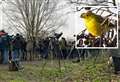
Thunderstorms are rolling through Kent this evening as train services are disrupted and people report torrential rain.
The bad weather comes after the Met Office issued a yellow thunderstorm warning for central and southern England from 1pm today (August 1) until midnight.

As the storm hit, Tunbridge Wells residents took to social media, with one describing “torrential rain”.
And another adding: “We have a spectacular thunderstorm going off near Tunbridge Wells. Crack of thunder like a bomb going off!”
This evening, Southeastern railway announced a temporary 40mph speed limit between Tonbridge and Wadhurst following reports of heavy rainfall in the Wadhurst area.
A spokesperson said via X that affected trains could be delayed by up to 15 minutes through the area and that weather forecasts were being monitored.
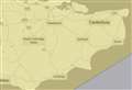
Forecasting images show heavy rain moving east across Tunbridge Wells and Sevenoaks towards Maidstone.
A Met Office spokesperson said: “Scattered slow-moving heavy showers and thunderstorms are expected to develop through this afternoon and evening, particularly across parts of central and southern England, and perhaps also east and southeast Wales.
“Whilst not all areas will see them, where they do occur torrential downpours could produce 50 mm or more in 1-2 hours, with a small chance of isolated 100 mm accumulations where multiple showers/storms move over the same area during the course of a few hours, leading to the risk of surface water flooding.
“In addition, thunderstorms may be accompanied by gusty winds, frequent lightning and large hail.
“Showers and thunderstorms will only slowly fade through the evening hours, and may persist or even re-develop during the overnight period in parts of eastern England.”