Unlimited Digital Access / Get £25 off your Annual Digital Subscription! Use code 25OFF
GET STARTEDMore on KentOnline
Unlimited Digital Access / Get £25 off your Annual Digital Subscription! Use code 25OFF
GET STARTEDMore on KentOnline
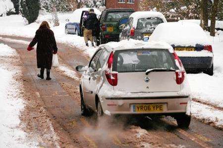
Kent faced up to the whitemare before Christmas today as snow blizzards caused chaos on the county's roads.
There are severe delays in Tunbridge Wells tonight and the M20 has been hit by tailbacks.
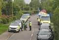
In Pembury the northbound A21 was closed this afternoon after a multi-car pile-up.
Side roads around Lamberhurst quickly became impassable as snow continued to fall during the afternoon.
In Ashford traffic has been brought to a standstill in and around the town centre by a jackknifed lorry.
The lorry broke down on Fougeres Way, Ashford, at around 1pm leading to long tailbacks.
Fougeres Way is the dual carriageway linking the Drovers roundabout to the M20 motorway.
Drivers at the scene reported vehicles stretching all the way to the slip road from the M20's Junction 9.
The problem was made worse as the area is currently undergoing major roadworks as part of the M20/Drovers roundabout improvement scheme.
In Chatham, two cars crashed into neighbouring houses in Thorold Road, at the bottom of Grange Hill at about 1.05pm.

A blue Toyota Avensis and a white van both collided with properties in the road with one house suffering severe damage.
Nobody was injured.
Kent Police have responded to the snow by issuing their sternest warning yet that the county's roads are extremely dangerous.
Superintendent Peter Wedlake, from Kent Police's Tactical Operations department, also warned Operation Stack may be implemented.

He said: "Anyone travelling this weekend should be prepared for delays and hazardous conditions.
"Kent Police is working with partner agencies to keep traffic on the road network moving, but some roads will clearly be more affected by the icy conditions.
"Motorists should be prepared. Please consider your safety and decide if your journey in these conditions is really necessary.
"If you do travel, make sure you have provisions for emergencies.
"We are expecting a high volume of traffic to leave Kent to travel to Europe this weekend which, together with the forecast conditions, may lead to the implementation of Operation Stack.
"If you have elderly or vulnerable neighbours or relatives, please remember to check on them to ensure they are safe and well.
"Pedestrians are also reminded to take great care, as icy conditions continue to make footpaths dangerous."
Families have been left worrying they could be left without presents if deliveries aren't made because of the ice.
One present-giver - who did not want to be named - said: "It's awful.
"I thought I was getting ahead of myself online, but I'm going to have to make other arrangements."
Temperatures hit -5C this morning but look set to plunge to an icy -7C tonight.
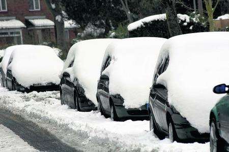
Two inches of the white stuff has already fallen in Maidstone, pictured above.
And heavy snow has settled in Medway, Canterbury and Dartford after a flurry this afternoon.
There was "a very slight smattering of snow" in Ashford but it hasn't settled.
In Larkfield there was around one inch of snow. But in Thanet there was "blue skies and fluffy white clouds".
More snow could fall over the weekend as the Arctic blast continues and motorists have been warned to expect treacherous roads.
The Met Office has issued an ice warning - with Kent and the South East expected to be among the worst hit places in the UK.
Weather expert Shaun Maltby, who runs www.kent-weather.co.uk, said: "For this morning's data we are looking at some more snowfall.
"Kent's top temperature's should hit the magical 0C in light but chilly north westerly winds.
"For this evening and into the night any remaining snowfall should clear away but with the chance of some snow cover, it will really hold back the temperatures with forecast low's of -7C, even lower for the more rural areas. "This means ice can form again for Saturday."